
County: Mayo Site name: HUT CIRCLE SITE, SLIEVEMORE
Sites and Monuments Record No.: N/A Licence number: 10E0281
Author: Stuart Rathbone
Site type: Early medieval industrial buildings
Period/Dating: —
ITM: E 461592m, N 806582m
Latitude, Longitude (decimal degrees): 53.989929, -10.110673
The Hut Circle Site is located on the southern slope of Slievemore, Achill, Co. Mayo. It is part of a dense archaeological landscape concealed by blanket bog on the southern side of the mountain, consisting of Neolithic tombs, Bronze Age roundhouses and a large pre-bog wall system. An early medieval ecclesiastical site is located at the foot of Slievemore; a cashel a little to the east of the ecclesiastical site was destroyed in the early 20th century.
The Hut Circle Site was first surveyed by the Achill Field School in 2008, when two subcircular foundations were identified on a poorly defined terrace measuring 30m north–south by 10m. In total, five trenches have been excavated at the site, with work taking place in August 2010 (Excavations 2010, no. 505) and then beginning again in May 2011 and being completed in August of that year. Trench 1 was located over the northern foundation and the area to its south and measured 10m by 7m. The northern foundation consisted of a subcircular drystone wall measuring 4.6m north-west/south-east and surviving to a maximum height of 1.2m; the building was set directly on top of the mineral soil. The internal area was small, with a maximum length of 2.6m from north-west to south-east, and was devoid of post-holes or other features indicative of a timber superstructure. A small hearth and a small pit were identified near the south-western and north-eastern perimeter respectively. Above the mineral soil there was a thin deposit of charcoal-rich dark sandy soil, from which a radiocarbon date of AD 717–888 was acquired. Above this soil there was a small amount of collapsed stone and then a layer of dark silty soil. An entrance was located in the north-western side of the structure, which had been around 1.8m wide. A neat pathway of three large stone slabs led up to this entrance from the north-western corner of the trench, and post-holes were located on either side of the path immediately beyond the outer wall face. The entrance had subsequently become infilled by a layer of soil, on top of which several courses of rough stonework had been placed.
It appeared that the southern side of the building overlay an earlier east/west-running drystone wall that turned sharply to the south at the extreme east of the trench. A large square area of apparently disorganised stone, 4m across, was located to the south-west of the foundation and south of the stone wall. The nature of this square feature was not established but it may have been another collapsed building, or a collapsed wall of some sort.
The exterior of the northern foundation was overlain by small spreads of collapsed stone followed by deep layers of dark, charcoal-rich soil, and a radiocarbon date of AD 653–770 was acquired from the lowest of these soils. To the south of the building there were large expanses of red ash within these overlying soils, as well as several small hearths. A reasonable depth of peat had built up over these soils.
At a distance of 2.75m to the south of the subcircular foundation a subrectangular foundation was identified. This had its long axis aligned from north to south and measured 3.2m by 2.8m externally. The wall consisted of one or two courses of neatly arranged stone and there was a narrow entrance in the middle of the eastern wall. A hearth was located in the centre of the internal space. It is not clear whether this foundation was ever covered by a superstructure, but if it had been then the superstructure must have been of a very light and insubstantial nature. This foundation was constructed into the top of the dark soil layers, indicating a later date than the subcircular foundation, and it was directly overlain by the base of the peat deposits.
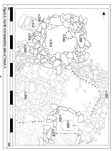
No. 458. Hut Circle Site, Slievemore: mid-excavation plan, Trench 1.
Trench 2, measuring 11m by 7m, was excavated over the southern foundation and the area to its south. The mineral soil in this trench was overlain by a sandy, charcoal-rich, light-coloured soil, which in turn was overlain by a dark, charcoal-rich silty soil on which the subcircular foundation had been built. The southern foundation consisted of a subcircular drystone wall, measuring 5m from north-west to south-east and surviving to a maximum height of 0.8m. The internal area was small, with a maximum length of 2.1m from north-west to south-east. The interior area was largely filled by a large rectangular box, aligned north-west to south-east and formed of thin, upright stone slabs, which measured 1.6m by 0.6m internally. The interior of the box had been excavated down to the top of the underlying light-coloured sandy soil. It was filled by heavily burnt orange soil and overlain by a thin and very charcoal-rich deposit from which a radiocarbon date of AD 663–858 was acquired. At the south-east the box connected to a narrow passage, just 0.3m wide and 1.1m long, running through the south-eastern portion of the building’s wall. It is thought that this passage represents a flue, whilst the stone box is thought to represent a kiln or a furnace. There were no other breaks in the structure’s wall. Two small post-holes were located immediately north-west of the stone box, in the narrow gap between the end of the box and the inner wall face.
A large drystone wall was found coming from the north-eastern side of the subcircular foundation, heading in a direction that suggested that it was a continuation of the wall found in Trench 1 and which underlay the northern foundation. The wall appeared to have been set on the top of the lighter sandy soil, and so it is likely that it pre-dates the subcircular foundation and that the wall had simply been demolished to allow for its construction. A small pit and a drainage channel were found in the area to the north-west of the subcircular foundation, cut into the top of the sandy soil. As with Trench 1, there was only a small amount of collapsed stone around the exterior of the building, and this was covered by deep deposits of charcoal-rich dark soil. A large concentration of red ash was found in the area immediately beyond the south-eastern flue above the lowest of the dark soils. Within the interior a series of dark, charcoal-rich soils overlay the stone box and filled the interior of the building. A small hearth was located in the centre of the building, set into the uppermost of these soil deposits. Above these soils there was a large quantity of collapsed stone filling the rest of the internal space, and it is suspected that the original wall height must have been much higher than had survived. Peat deposits overlay the charcoal-rich dark soils and the uppermost parts of the subcircular foundation.
A rather flimsy subrectangular foundation had been tagged onto the southern side of the circular building, causing some damage to the southern side of the flue. This measured 3.5m from north-east to south-west and 2.5m from north-west to south-east. It was defined by a simple wall made of two or three neat courses of stones. A possible entrance was located on its south-eastern side and a shallow hearth was found in the centre of the building. This small structure was very similar in nature to the one found in Trench 1; it, too, had been constructed high up in the overlying dark soil deposits and was therefore clearly later in date than the subcircular foundation.
No. 458. Hut circle site, Slievemore: mid-excavation plan, Trench 2.
A substantial pre-bog stone wall appeared to begin just to the north-west of the terrace and then headed up the mountain, following a zigzagging northerly course for almost 200m. This wall was investigated in Trenches 3 and 4. Trench 3 was located 10m to the north of Trench 1 and measured 6m by 1m. The wall in this trench was 2.1m wide and 0.5m tall, and there were build-ups of collapsed stone on either side. The wall lay directly on the mineral soil, as did the collapse, and both were overlain by a deep series of peat deposits. Trench 4 was located 10m north of Trench 3 and measured 6m by 2m. The wall in this trench was 3m wide and up to 0.8m tall, and there were build-ups of collapsed stone on either side. The wall lay directly on the mineral soil, as did the collapse, and both were overlain by a deep series of peat deposits. A second substantial pre-bog wall ran past the southern end of the terrace, this time running for 50m off to the east and several hundred metres off to the west. It was investigated in Trench 5, which measured 6m by 2m. The wall in this trench was up to 1.45m wide and 1.05m high and there was collapsed material on either side. The wall rested on the mineral soil, as did the majority of the collapse, and both were overlain by deep peat deposits. Interestingly, a small area of collapsed material was located north of the wall within the peat deposits, indicating a second, much later, phase of collapse.
Finds from the excavations were largely limited to a small number of undiagnostic flint flakes and a huge quantity of smashed-up pieces of milky white quartz. Three small glass beads of early medieval date were found in Trench 2: one from the dark soil underlying the wall of the subcircular foundation, the other two from the dark soil overlying it. It therefore seems that the site consists of a small industrial complex belonging to the early medieval period, and a particularly intriguing possibility is that the kiln or furnace was being used to burn the milky quartz for some reason, possibly to do with mineral extraction or perhaps even as part of the manufacture of glass. The date of the adjacent pre-bog walls is currently unknown, but others in this area of the mountain have been shown to belong to the Bronze Age.
Achill Field School


